Creating Opportunities for the Future While Protecting the Sandhills
August 6, 2021
Ulteig Engineers Help Custer PPD Replace 38 Miles of Aging Transmission Line in the Heart of Sandhill Crane Country
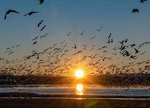
From mid-February to mid-April, one of the greatest events in our natural world occurs throughout the Sandhills region of central Nebraska—the migration of more than 500,000 sandhill cranes from their winter-feeding grounds in Texas to their summer breeding grounds in northern Canada and Alaska.
This incredible event attracts bird watchers from throughout the world who travel to central Nebraska to witness tens of thousands of sandhill cranes resting before they take flight in their journey North.
And it is out of respect for these beautiful birds and what they mean to Nebraskans—as well as bird lovers throughout the world—that Custer Public Power District (Custer PPD) challenged Ulteig engineers to create an avian-safe design when replacing 38 miles of aging transmission line between Seneca and Dunning, Nebraska. The line, which runs parallel along Highway 2, is situated in Nebraska’s famous Sandhills region, a semi-arid area encompassing 19,300 square miles that features rolling, grass-covered sand dunes. Once populated by tens of thousands of buffalo during the 1800s, today the Sandhills area is known for Nebraska’s famous grass-fed cattle and its world-class golf courses.
“This line is constructed through some fragile land with many forms of wildlife,” said Rick Nelson, general manager of Custer PPD. “Ulteig’s attention to detail and ability to address our concerns pertaining to the migratory birds that fly the area, and the fragile soil of the Sandhills of Nebraska, was really important to this project’s success.”
Custer PPD, headquartered in Broken Bow, is geographically the largest rural public power district in Nebraska, serving over 8,000 square miles of territory in the central part of the state. Custer PPD supplies electric power with approximately 300 miles of transmission lines and over 4,600 miles of distribution lines to Custer, Thomas, Blaine, Logan, McPherson, Loup, and Hooker counties and portions of Sherman, Dawson, Cherry, Lincoln, Brown, and Garfield counties. Custer is divided into six service areas, two of which are served out of the main headquarters in Broken Bow. The other four areas have their own service centers strategically located within their service area.
“This project includes converting the operating voltage of the line from 34.5 kV to 69 kV, said Kelly Bjerke, technical manager with Ulteig’s transmission team. “In addition, with the new, higher voltage line, we needed to not only replace the original wooden poles, most of which were installed in the mid-1950s, but also increase their height. We specified new steel poles up to 120 feet in length; however, most of the poles will be in the 75- to 85-foot range.”
Replacing this transmission line is part of Custer PPD’s long-term plan to modernize its electrical grid system.
Thinking Birds
This was the first time Ulteig had ever been asked to conduct avian and other environmental studies as part of a Custer PPD transmission line design project.
The environmental analysis involved conducting two primary studies. Because the new transmission line would be in close proximity to the Middle Loop River, Ulteig first conducted a study of nearby wetlands. These areas are known to provide habitat for federally protected species such as the piping plover, whooping crane and the northern long-eared bat, among others. The results of this study helped designers place new poles in locations that avoided impacts to wetlands.
Since overhead power lines may pose electrocution and collision risk to birds, a separate avian risk assessment was conducted to analyze the potential impacts the upgraded transmission line may have on sandhill cranes, eagles, and other birds in the area. This assessment incorporated guidelines as published by the Avian Powerline Interaction Committee (APLIC) as well as Custer PPD’s Avian Protection and Management Policy.
Custer PPD made the decision to have the new line designed and constructed with greater separation between the energized conductors themselves as well as between the energized conductors and grounded parts, as suggested by APLIC. This increased separation reduces the likelihood that a perched bird will simultaneously contact energized and/or grounded equipment and be electrocuted. If adequate separation could not be incorporated into the design, insulation covers were used to cover phases or grounds to reduce avian electrocution risk.
Because the project is located within the central flyway migration corridor, Ulteig’s environmental team also had to analyze the risk of avian collisions with power lines and equipment. This assessment analyzed susceptible bird groups, protected species, migration patterns, spatial resources and previously documented interactions to identify specific locations along the 38-mile corridor that may present a higher risk of collision for birds.
“The problem is that birds can have difficulty seeing and avoiding transmission line conductors, particularly those with a smaller diameter such as the shield wire attached to the top of the poles,” said Luke Hodges, Ulteig environmental specialist. “So, the installation of line marking devices on the shield wire was recommended. These devices help birds identify the lines and avoid collisions, especially in low light conditions or inclement weather.
Refined Survey Techniques Inform Design, Minimize Impact
Ulteig’s field services group first performed a topographic survey of the project corridor, which was incorporated into the design for the new transmission line. The topographic survey consisted of mapping a corridor, 100-feet wide, along the existing alignment and client- or landowner-specified deviations. An aerial survey wasn’t possible due to snow coverage, so a traditional ground survey was performed. “Because we understand landowner concerns over erosion caused by delicate vegetation being disturbed, the survey team walked the corridor on foot,” said Jay Johnson, field services technical manager. “This minimized the impact to the sensitive environment that is the Sandhills area.” They also made notes, utilizing the mobile GIS-based project map, to identify areas of access that would help everyone throughout the construction process.
The field services group also performed retracement surveys for parcel boundaries, road right-of-way and riparian rights, preparing the documents necessary for the easement acquisition process. This consisted of researching all parcels impacted by the project. The team also worked with the county-appointed surveyors to restore lost section corner monuments along the route. This service is traditionally provided by the county surveyor at the county’s expense, but due to the large scope of this project, the county’s surveyors chose to work with Ulteig’s surveyor team to restore the missing corner locations and place new monuments.
Finally, the field services group completed preliminary pole staking for landowner and county review. They then performed the final construction staking, marking the locations of the new poles and guy anchors for the construction companies.
In all, this effort included team members from four different office locations mobilizing to the site and assisting in the calculation and drafting of deliverables. The team was often able to mobilize to the site with less than 24 hours’ notice.
Construction Tracker Application Provides Map to the Future
Another important aspect of this project was the customized, web-based, digital mapping system that Ulteig created to provide quick and easy access to the survey notes, easements and design. To support field inspectors and contractors, Ulteig developed a mobile application and a dashboard to visualize the key construction installation progress.
Ulteig created the GIS-based project map, accessible from a desktop computer or a mobile device, to track numerous factors along the transmission line corridor, including structure install status, landowner easements, special landowner instructions, construction notes, FAA permitted structures, and laydown areas for materials. Additional tools included a smart form daily log app and custom-printed forms with access to geo-referenced plan and profile design drawings. The project map became a powerful information tool for Custer PPD as well as construction contractors.
“Our client initially asked for some map books,” said Mike Schnetzer, Ulteig senior GIS analyst. “Instead, we provided a more intuitive solution utilizing GIS technology by creating a project web map, a mobile app and construction tracking dashboard application. This provided all project stakeholders quick and easy access to critical project information.”
End results
Once completed, this project will give Custer PPD:
- A new transmission line that will last for at least 50 years
- More reliable and efficient electricity transmission
- Voltage support over the long distance
The Seneca to Dunning project consists of three segments:
- Seneca to Thedford: The first segment of approximately 14 miles uses guyed, engineered class steel poles and 161 kV rated insulators for increased conductor spacing. The transmission circuit phase conductors are T2-2/0 aluminum conductor steel-reinforced (ACSR) cable, and the underbuilt distribution circuit phase conductors are T2-1/0 ACSR. The transmission line shield wire, which also serves as a neutral conductor for the distribution circuit, is also T2-1/0 ACSR conductor.
- Thedford to Halsey: The second segment connects to a line that was recently rerouted on the east side of the Nebraska Public Power District (NPPD) Thedford Substation. This segment is approximately 14 miles in length and uses the same pole and conductor types noted above for the first segment.
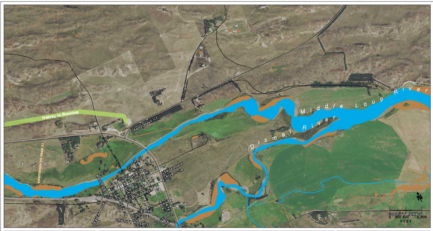
- Halsey to Dunning: The third segment is approximately 10 miles long and also uses the same pole and conductor types noted above for the first segment.
Construction on the project was launched in late November 2020 and is expected to be complete by April 2022.
Lessons Learned
While a large-scale transmission line upgrade project isn’t anything new to Ulteig, this project proves that even the most straightforward project can offer new challenges and opportunities to innovate.
WHAT MAKES ULTEIG DIFFERENT?
From global energy producers to locally funded cities and private developers to government agencies, the clients we serve encompass a broad range of relationships and projects. Find out why Ulteig is a leader in the engineering industry.
Contact Us