Increase Cost Effectiveness by Incorporating GIS Into Your Next Project
September 1, 2020
We are constantly seeking new ways to improve the way work is performed. A recent Ulteig innovation involves the integration of 360-degree video with GIS. We call it 360 VMI: Video & Mapping Integration. We’re using 360-degree cameras to collect videos of project areas by attaching the camera to a vehicle or walking down a corridor. This video is then integrated into our web mapping system to allow the user to click on a map and start the video at the time stamp of that exact point. This application reduces the number of return trips to the field and gives us yet another innovative tool to communicate more difficult design situations with our internal staff and clients. Because innovation has no finish line.
Ulteig has a long history of providing centralized Geographic Information Systems (GIS) solutions to support our key Lifeline Sectors® of Power, Renewables, Transportation and Water. These GIS solutions are invaluable to the success of our projects. GIS technology supports engineering projects by combining the visual benefits of mapping with the power of a database. The technology contributes to data asset management and project status tracking, and enhance communications between stakeholders throughout the project.
More Efficiency, Less Cost
One of Ulteig’s benchmarks for the value of GIS is a project developed for a Midwest electric utility company. This project received a National Recognition Award by the American Council of Engineering Companies for its design excellence.
While the designs developed by our engineering team were very accurate and met the client’s expectations, the team felt the project could be more efficient. Using GIS-based databases, workflows and applications, the team completely revamped the process to improve efficiency and deliver additional benefits from a new workflow. The Ulteig project team created a plan to meet project requirements by using GIS in field mapping applications integrated with centimeter-accurate GPS antennas and efficient GIS workflows for client deliverables creation.
Drawing on our experience with this project and others, here are six learnings for using GIS on your next project:
- Don’t be afraid to question a good process. We had a good process in place and met the expectations of our client, but we realized it could be even better with the use of GIS technology. Challenging traditional thinking led to the development of a revamped approach to energy distribution design. By utilizing GIS technology, we increased the efficiency of this particular energy distribution design project, and now we look forward to leveraging GIS to other projects involving other industries to enhance project efficiencies. At Ulteig, we are continuously seeking new ways to shorten project timelines and enhance real-time project updates with fewer paper markups and corrections.
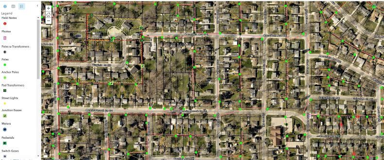
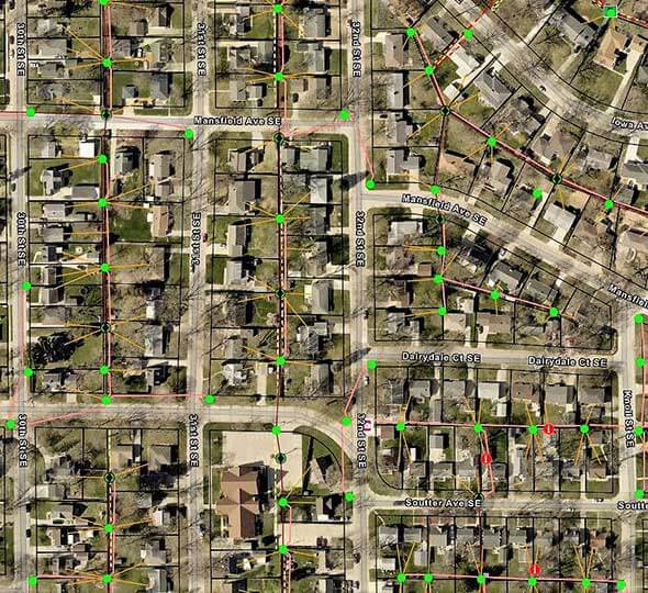
- Choosing the right hardware and software is imperative. In incorporating GIS technology into the project, our Midwest Electric Utility team at Ulteig carefully considered the hardware and software with an eye toward efficiency. Of course we wanted to obtain the right data and of course we wanted to obtain as much useful data as possible. But what about the most relevant data? And what about data that can easily be shared and combined with data from other sources and make the entire work flow smoother? So, again, with an eye toward efficiency, we combined ESRI Collector for ArcGIS with Trimble survey-grade GPS receivers connected to ruggedized tablets to collect field data. The data created became an interactive inventory-map of the client’s existing utilities (poles, transformers, junction boxes, etc.), which was accurate to the centimeter and provided the data necessary to begin and carry out the design process. Pictures also were taken and attached to the collected features for later reference. Through integration with the utility’s GIS, the team could overlay available GIS data from city, county and utility databases. Using the collected existing utilities data and background data from other entities, we created a better design within the GIS application.
- Leverage cloud-based web services to share real-time data. Leveraging cloud-based web services made it possible to share real-time design and right-of-way (ROW) easement acquisition data and project updates among all participants. This eliminated the need for redlined paper maps and minimized time-intensive conversations about design corrections. The inventory database and project updates were immediately accessible to designers, field engineers, surveyors, ROW agents and project managers, all connected by the application and its data, keeping all participants informed and on the same page.
- Communicate early and often with key stakeholders, such as landowners. By proactively communicating early and often with landowners about acquiring easements and informing residents of proposed new equipment, we built trust. This was essential to the project’s success. To facilitate this communication, we created landowner communication maps. Live ROW and distribution data was incorporated into these maps, which allowed adjustments to be made on the fly when there were design changes or landowners refused easements. ROW, survey and design could use GIS to collaborate as a single team instead of independent silos. Addressing landowner concerns early in the process allowed for adjustments and prevented unnecessary and costly construction delays.
- Leverage technology to better manage your time. All construction projects are driven by the proper management of time. Good time management can increase efficiencies, improve consistency and reduce costs. The Ulteig team developed a proprietary scripting process, which created final design PDF maps, ensuring a consistent and cost-effective product. The interactive GIS applications used throughout the project not only kept a constantly updated and accurate inventory of existing utilities, but also decreased in-field survey and in-office design time.
- Never reach the finish line. Continue to find new ways to improve the way work is performed. For example, Ulteig recently added the use of 360-degree video cameras to collect videos of project areas by attaching the camera to a vehicle or walking down a corridor. This video is then integrated into our web mapping system to allow the user to click on a map and start the video at the time stamp of that exact point. This application reduces the number of return trips to the field and gives us yet another tool to communicate more difficult design situations with our internal staff and clients.
Benefits of a GIS App
In summary, GIS has become a critical part of the Ulteig planning process. It’s a technology that we believe should be considered for most projects. Here are the benefits that we’ve identified:
- Creating interactive inventory-maps
- Sharing updated data in real-time with staff in the field and in the office
- Decreasing survey and design time
- Flexibility to scale data to the project parameters
- Eliminating separate copies and versions of designs and data from a centralized database
- Referencing facilities data such as size and type, and pictures from the office
- Increasing accessibility to data
- Tracking the status of design, construction, and easement acquisition
- Connecting with intuitive modern smartphone apps and web apps
The Bottom Line: Consider GIS to Enhance Your Next Project
GIS technology is one of many innovative surveying services that Ulteig tailors to meet the unique needs of our clients. Our team uses the most advanced GIS software in the industry to provide customized geospatial solutions built around your business requirements. Ulteig’s wide-ranging GIS solutions range from data collection and custom mapping to GIS server solutions and technical support for utilities, commercial organizations and various levels of government. Our GIS service offerings include:
- GIS Implementation Planning
- GPS utility data collection
- As-built document scanning and map data integration
- Web and mobile GIS applications
- ArcGIS Online Setup and Training
- Site Selection Analysis
- 3D Modeling
If you’ve wondered if GIS should be incorporated into your next project, contact our GIS team at Ulteig. We can help you better understand the advantages of GIS both in the planning and building of your project, but also for the long term, when your project will need maintenance, retrofitting or repowering.
By Dan Haglund, Distribution
 Dan Haglund is Ulteig’s Distribution Design Supervisor as part of the Field Services Team. He has more than 20 years of experience in implementing GIS solutions. He takes pride in finding ways to utilize GIS in practical and beneficial ways to improve efficiency, communicate better, and effectively manage projects.
WHAT MAKES ULTEIG DIFFERENT?
From global energy producers to locally funded cities and private developers to government agencies, the clients we serve encompass a broad range of relationships and projects. Find out why Ulteig is a leader in the engineering industry.
Contact Us