Utilizing GIS Technology for Field Based Distribution Design

July 31, 2020
One of our power clients reached out to us in search of a solution for a field-based design approach for electric distribution projects they were constructing in the Midwest. Ulteig created a plan to meet their project requirements by utilizing a GIS centric solution.
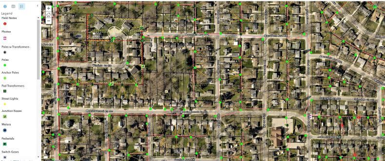
The solution involved a combination of developing GIS databases, publishing web services in the cloud, and building web and mobile applications to support the project workflows. Another key component of the solution was to identify the appropriate high accuracy GPS receiver that meet the accuracy requirements of the project.
Ulteig engineers combined the cloud-based web services and ESRI Collector for ArcGIS mobile app with a Trimble survey-grade GPS receiver connected via Bluetooth to computer tablet to collect the data. The field data then became an interactive inventory-map of the existing utilities (poles, transformers, junction boxes, etc.). The measurements were accurate to the centimeter and provided information necessary to carry out the design process. Through integration with the power utilities’ GIS, the Ulteig team overlaid additional GIS data from city, counties, and utilities by connecting live to their web services, such as parcels, recorded easements, and aerial imagery.
Our engineers leveraged cloud-based web services that allowed us to share real-time design and right-of-way (ROW) easement acquisition data and project updates. This service helped eliminate the need for redlined paper maps and minimized the time-intensive design conversations necessary for any design corrections. Inventory database and project updates were immediately accessible to designers, field engineers, surveyors, ROW agents, and project managers, keeping all participants informed and on the same page.
Relatively early in the design process, Ulteig’s ROW staff begin communicating with landowners to acquire easement and to inform residents of proposed new equipment. Ulteig’s system enabled the automated creation of landowner communication maps. Live ROW and distribution data were incorporated into the same maps, allowing adjustments on the fly for design changes or landowners who refused easements. ROW, survey and design team members used GIS to collaborate as a single team instead of independent operators.
Addressing any landowner concerns early in the process allowed for adjustments and prevented unnecessary and costly construction delays. The Ulteig team developed a proprietary scripting process that created final design PDF maps, ensuring a consistent and cost-effective product. The interactive GIS applications used throughout the project kept an updated, accurate inventory of existing utilities and decreased in-field surveys and in-office design time.
This power utility project challenged traditional thinking and led to the development of a revamped approach to energy distribution design. By utilizing a GIS solution, engineers can increase the efficiency of energy distribution projects and be applied to other disciplines.
As electric utilities confront the ongoing challenge of delivering reliable power to customers, they also experience an increased need for partners who offer customized solutions to address evolving demands. Ulteig’s system efficiency solutions allow for shorter project timelines and real-time project updates with fewer paper markups and corrections, resulting in resource reductions benefiting the utility (costs and time), and natural resources (reduction in paper use).
WHAT MAKES ULTEIG DIFFERENT?
From global energy producers to locally funded cities and private developers to government agencies, the clients we serve encompass a broad range of relationships and projects. Find out why Ulteig is a leader in the engineering industry.
Contact Us

